


Big Bend National Park is divided into five sections. Take a minute to read through our orientation page information in order to familiarize yourself with the different areas within the park and ensure a great time when you visit.
Overview
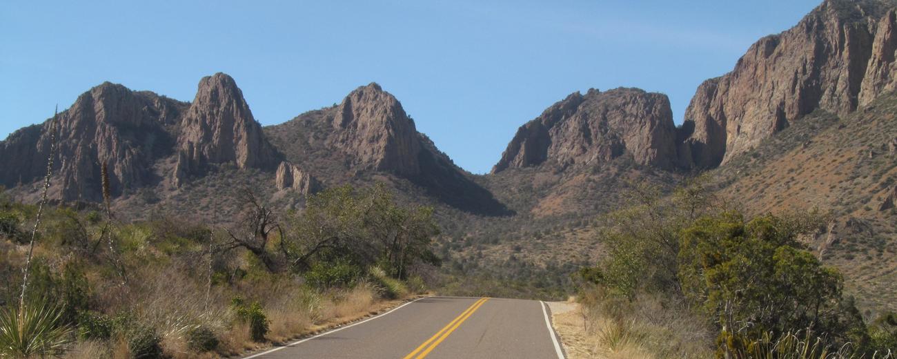
Big Bend may not be the largest national park, but it's more than large enough to get lost in. The park is divided into five sections: its center point at Panther Junction, Rio Grande Valley and its ruins of hot spring resorts and ore mines, Castolon with its ranches, deep canyons, and scenic drives, the mountainous Chisos Basin, and, lastly, the scarce-developed Persimmon Gap. Hiking is the primary activity in the park, although biking is close behind.
Areas of the Park
Panther Junction
Panther Junction is the headquarters of Big Bend, but sits at the center of the park rather than at its edge, so it's not the most quickly accessible of the park's areas. Still, it's a good place to start. After visiting the main visitor center, ease into Big Bend with a quiet hike up the Grapevine Hills Road and Trail. For desert-picnic lounging, try Dugout Wells. Croton Spring Road is another way to explore the park near Panther Junction, if it's rather rough.
Rio Grande Village
This area of the park rests not only on the river, but on the border between Mexico and the United States. Several hikes begin here, from the short Rio Grande Village Natural Trail and Boquillas Canyon Trail to the grueling Ore Terminal Trail and the Marufo Vega Trail. And as this is a hiker's park, the Ernst Tinaja and the Hot Springs Historic District both must be hiked. The Ernst Tinaja, a "tank" filled with water year-round, is hard to reach, but worth it. The Hot Springs Historic District preserves the remains of a hot springs resort and you can still soak here. Stop by Daniel's Ranch Picnic Area on your way; it's a great birding spot.
Castolon
Castolon is west Big Bend. Start at the Castolon Historic District and take the Ross Maxwell Scenic Drive, which ends at the famous Santa Elena Canyon, a deep, grand limestone canyon that divides the United States and Mexico. Hiking trails exist as detours off the main road, among them the Tuff Canyon, the Burro Mesa Pouroff and its hidden box canyon, and the Chimneys Trail. And when you've finally exhausted the Drive, the rough Old Maverick Road will take you further, if the 13-mile drive is rough indeed.
Chisos Basin
If Panther Junction is the headquarters of the park, this is its real center, and you can eat out and bunk in a hotel here if you'd like. The real draw is, of course, not the facilities, but that cliff-surrounded basin. This can be explored through a number of trails from the easy Window View Trail to the moderate Lost Mine to the backpacking 30-mile marathon, the Outer Mountain Loop. The highest point of Big Bend juts from the side of the basin; this is Emory Peak and is also hikeable.
Persimmon Gap
This north end of the park is also the least developed. Stop by the Fossil Bone Exhibit and explore the desert through the Dagger Flat Auto Trail, which ends in a Giant Dagger Yucca forest. Dog Canyon is accessible through a moderately strenuous trail, and Devil's Den, another canyon, is also hikeable, as is Persimmon Peak.
Other Things to Know
Big Bend National Park is only accessible by car. You can get there from taking TX 118 from Alpine, US 90 or US 385 south from Marathon, or FM 170 from Presidio. Once within the park, you can explore it via car, foot, or, most likely, some mixture of both. Be aware that Big Bend is an isolated place and that although there are camper stores within the park, it's best to be well-supplied before you visit. Also be aware that Big Bend can get dangerously hot in the summer and bringing plenty of water is always essential.
Pets
Be aware that having a pet with you will limit your activities and explorations in the park. In addition, desert temperatures and predators are a serious threat to your pet's well being. Please consider the following points before deciding to bring a pet:
- Pets are not allowed on trails, off roads, or on the river. Basically, your pet can only go where your car can go.
- If you plan to hike, someone must stay behind with the pet, or you will need to make arrangements with a kennel service.
- Pet owners are required to immediately remove and properly dispose of fecal matter deposited by their pets. Deposit bag of fecal matter in a dumpster.
- Pets need to be on a leash no longer than six feet in length (or in a cage) at all times.
- You are not allowed to leave your pet unattended in vehicles if it creates a danger to the animal, or if the animal becomes a public nuisance. There is no kennel service in the park.
- Pet etiquette and park regulations require that you always clean up after your pet and dispose of waste in trash receptacles.
- Predators such as owls, coyotes, mountain lions and even javelina can and do kill pets here. Even large dogs cannot defend themselves against predators. Extreme temperatures are also a danger.